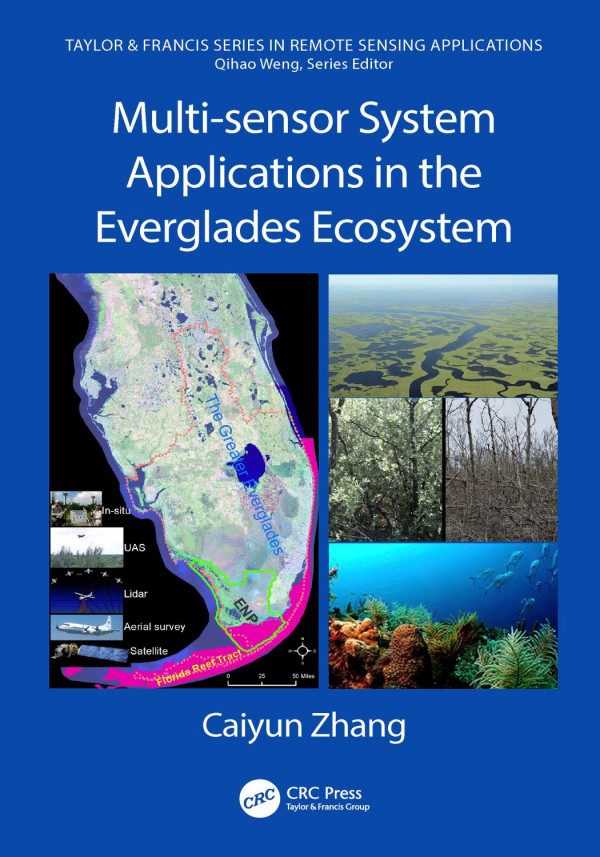
Multi-sensor System Applications in the Everglades Ecosystem 1st Edition by Caiyun Zhang 0429530781 9780429530784

Original price was: $50.00.$25.00Current price is: $25.00.
Multi-sensor System Applications in the Everglades Ecosystem 1st Edition by Caiyun Zhang – Ebook Instant Download/Delivery ISBN(s): 0429530781, 9780429530784
Product details:
- ISBN 10: 0429530781
- ISBN 13: 9780429530784
- Author: Caiyun Zhang
This book explores the applicability of multiple remote sensors to acquire information relevant to restoration and conservation efforts in wetlands using data collected from airborne and space multispectral/hyperspectral sensors, light detection and ranging (LiDAR), Unmanned Aircraft Systems (UAS), and a hand-held spectroradiometer. This book also examines digital data processing techniques such as object-based image analysis, machine learning, texture analysis, and data fusion. After an introduction to the Everglades and to remote sensing, the book is divided into four parts based on the sensor systems used. There are chapters on vegetation mapping, biomass and water quality modeling, applications of hyperspectral data for plant stress analysis and coral reef mapping, studies of airborne LiDAR data for coastal vulnerability analysis and DEM improvement, as well as chapters that explore a fusion of multiple sensors for different datasets.
Table of contents:
Part I: Florida Everglades and Remote Sensing
1. Florida Everglades and Restoration
2. Introduction to Remote Sensing
3. Vegetation Classification Systems in the Everglades
Part II: Multispectral Remote Sensing Applications
4. Applying Aerial Photography to Map Marsh Species in the Wetland of Lake Okeechobee
5. Unmanned Aircraft System (UAS) for Wetland Species Mapping
6. Spaceborne Multispectral Sensors for Vegetation Mapping and Change Analysis
7. Water Quality Modeling and Mapping using Landsat Data
8. Mapping Sawgrass Aboveground Biomass using Landsat Data
9. Applying Landsat Products to Assess the Damage and Resilience of Mangroves from Hurricanes
Part III: Hyperspectral Remote Sensing Applications
10. Applying Point Spectroscopy Data to Assess the Effects of Salinity and Sea Level Rise on Canopy Water Content of Juncus roemerianus
11. Applying Point Spectroscopy Data to Characterize Sand Properties
12. Land Cover-level Vegetation Mapping using AVIRIS
13. Species-level Vegetation Mapping in the Kissimmee River Floodplain using HyMap Data
14. Benthic Habitat Mapping in the Florida Keys using EO-1/Hyperion
15. Vulnerability Analysis of Coastal Everglades to Sea Level Rise using SLAMM
16. Enhancing Lidar Data Integrity in the Coastal Everglades
17. Assessing the Effects of Hurricane Irma on Mangrove Structures in the Coastal Everglades using Airborne Lidar Data
18. Integrating Aerial Photography, EO-1/Hyperion, and Lidar Data to Map Vegetation in the Coastal Everglades
19. Assessing a Multi-sensor Fusion Approach to Map Detailed Reef Benthic Habitats in the Florida Reef Tract
People also search:
sensors used in building automation system
multi-sensor integration
multi-domain sensing system
ec-multi-sensor-ble
what is system sensor
You may also like…


Business & Economics
The Evolution of the Non market Economy Treatment in the Multilateral Trading System Bin Zhang


Computers - Security
Secure Image Transmission in Wireless Sensor Network WSN Applications K. Shankar


Biology and other natural sciences - Biophysics